



There are places you visit because they are beautiful.
There are places you visit because they are fun.
And then there are places like the Lapindo Sidoarjo Mud Volcano, where you stand on top of a massive dirt levee staring across what used to be entire neighborhoods and wonder how the hell something like this is still happening.
This is not one of Indonesia’s famous tourist attractions.
There are no tour buses lined up outside. No carefully manicured viewing platforms. No cafés selling $7 iced lattes beside a conveniently positioned Instagram swing.
In fact, when I told my driver I wanted to visit Lapindo, he questioned me several times to make sure I actually meant the mud volcano.
Yes. The mud volcano.
The enormous industrial disaster that buried villages.
That one.
Apparently this was not a particularly common request.
And that is precisely why Lapindo belongs among Indonesia’s most important dark tourism destinations. Not because visiting a disaster site is entertaining, but because standing where thousands of people lost their homes provides a perspective that photographs, statistics and history books simply cannot.
Nearly two decades after the disaster began, the earth is still coughing up mud.
And nobody can say with certainty when it will stop.
DESTINATION: Lapindo Sidoarjo Mud Volcano
GPS COORDINATES
-7.5257, 112.7257
CLOSEST AIRPORT
CURRENT WEATHER
few clouds (86F / 30C)

AIR QUALITY INDEX (AQI)
Unhealthy for Sensitive Groups (137)
The Day the Earth Puked
On May 29, 2006, hot mud suddenly began erupting from the ground near Sidoarjo, roughly 30 kilometers south of Surabaya in East Java.
Nearby, PT Lapindo Brantas was drilling the Banjar Panji-1 natural gas exploration well.
What happened next would permanently reshape the surrounding landscape.
Mud, water and gas began forcing their way toward the surface. What initially appeared to be a localized geological event rapidly escalated into something almost impossible to control.
The eruption became known as Lusi, short for Lumpur Sidoarjo, or Sidoarjo mud.
And Lusi was hungry.
At its peak, estimates placed the eruption at roughly 180,000 cubic meters of mud every day.
That’s about 72 Olympic swimming pools.
Every. Single. Day.

Except instead of water, imagine those swimming pools filled with hot sludge relentlessly pouring across neighborhoods, factories, roads and rice fields.
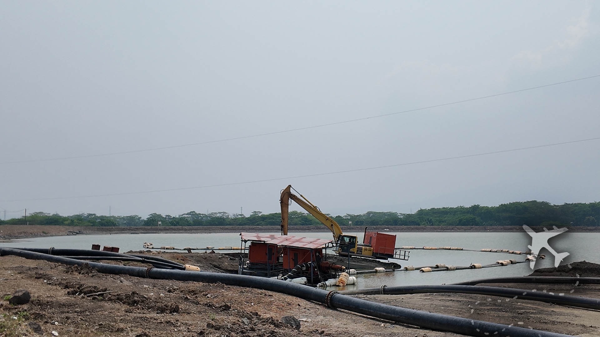
Engineers constructed enormous earthen levees in an attempt to contain it. The mud kept coming.
Pumps were installed. The mud kept coming.
More barriers were built. The mud kept coming.
Eventually, containment became less about stopping the disaster and more about deciding where the disaster was allowed to go.
SIXTEEN VILLAGES DIDN’T JUST DISAPPEAR. PEOPLE LIVED THERE.
Statistics make disasters wonderfully easy to digest.
Sixteen villages affected.
Tens of thousands displaced.
Thousands of homes destroyed.
Factories buried.
Schools lost.
Agricultural land ruined.
You can read those numbers from the comfort of your couch and move along to whatever other horrible thing the Internet wants you to think about next.
Standing here makes that considerably more difficult.
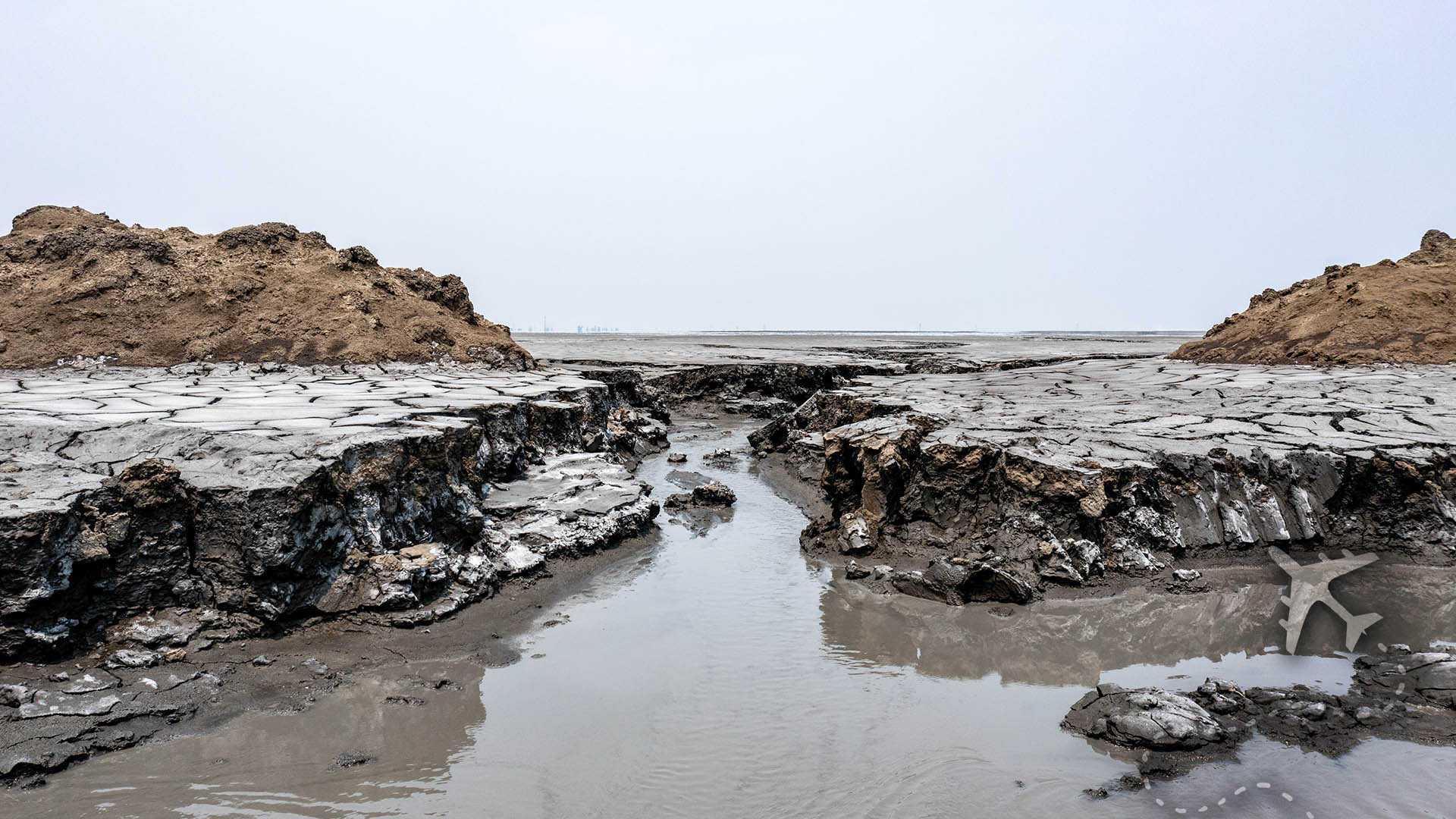
From the top of the levee, the disaster stretches toward the horizon.

This wasn’t empty land.
There were streets down there.
Homes.
Businesses.
Schools.
Rice fields.
Neighborhoods where people raised children, cooked dinner, went to work and presumably complained about their neighbors doing annoying neighbor shit.
Then the mud came.
People evacuated expecting they might eventually return.
Many never did.
Their communities didn’t burn down or slowly decay into abandonment.
They were buried.
That distinction becomes much more disturbing when you’re standing above them.
SO WHO CAUSED THIS SHIT?
Nearly twenty years later, the cause remains controversial.
One explanation connects the eruption to the drilling operation being conducted nearby by Lapindo Brantas. Researchers supporting this theory have argued that drilling operations created the pathway that allowed highly pressurized underground fluids to escape toward the surface.
Another explanation attributes the eruption to geological changes associated with the May 2006 Yogyakarta earthquake, which occurred two days earlier and hundreds of kilometers away.
The debate has produced years of scientific papers, corporate arguments, political controversy and legal battles.
For the people who lived here, the academic distinction probably offers limited comfort.
Whether the earth spontaneously decided to ruin everyone’s life or humans accidentally gave it some assistance, the result looks exactly the same from the top of the levee.
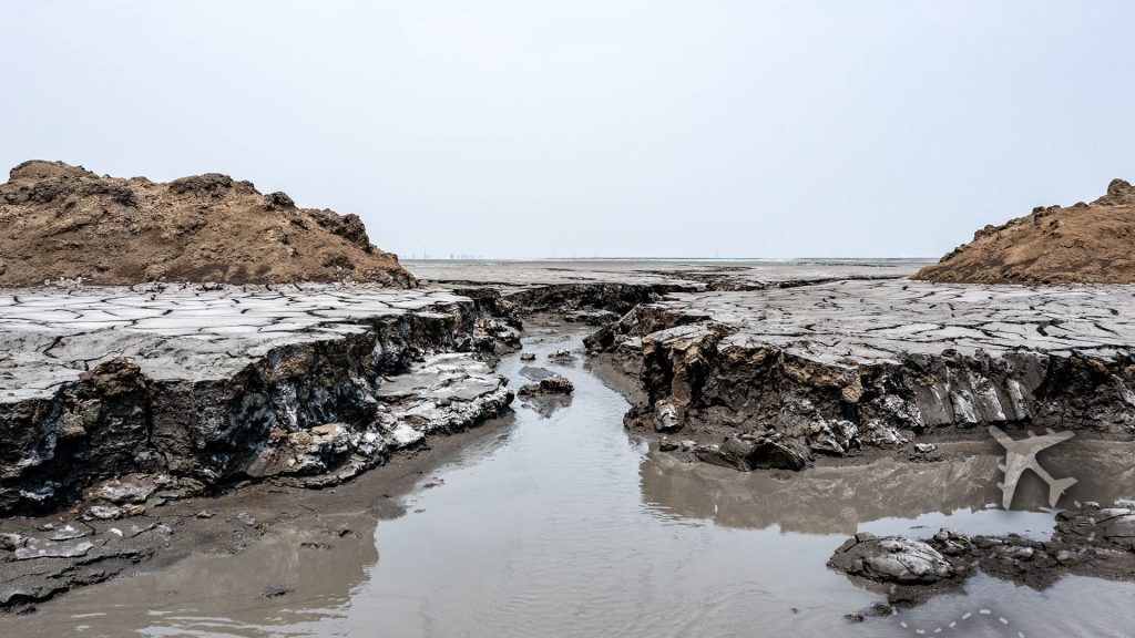
Their homes are still underneath the mud.
THE WORLD’S BLEAKEST PANORAMIC VIEW
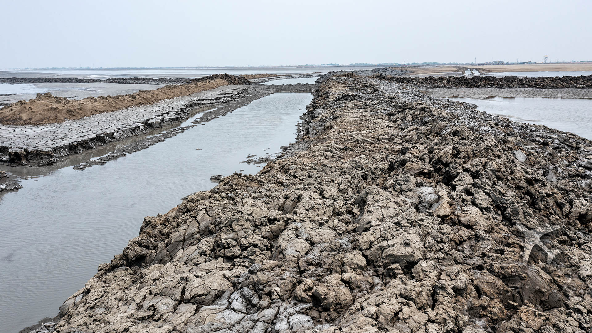
Eventually, I climbed onto the enormous containment levee surrounding the disaster zone.
From up there, you begin to understand the scale.
The landscape is almost aggressively empty.
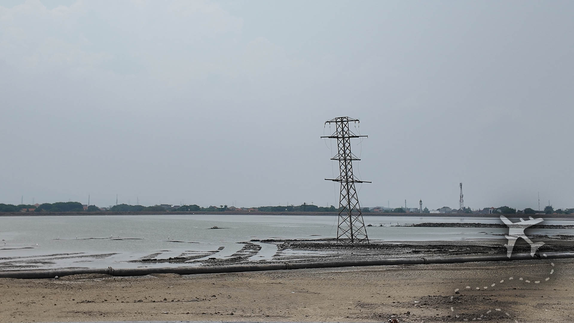
Huge expanses of gray and brown stretch toward the horizon, interrupted occasionally by water, machinery, smoke, vegetation trying to reclaim the edges and remnants of infrastructure that no longer serve much purpose.
It looks less like Java and more like someone selected “post-apocalyptic wasteland” from a movie location catalog.
Except this isn’t a movie set.

Beneath that mud are people’s former lives.
That’s what makes Lapindo different from many abandoned places.
At Centralia, Pennsylvania, an underground coal mine fire slowly drove residents away as toxic gases and unstable ground consumed the town from below.
Lapindo accomplished something similarly catastrophic with considerably more enthusiasm.
Both places exist because something beneath the ground escaped human control.
Both displaced communities.
Both fundamentally altered the landscape.
And both will probably outlive many of the people who witnessed the disasters begin.
THIS ISN’T REALLY A TOURIST ATTRACTION
Calling Lapindo a “tourist destination” feels a little like calling Pripyat a Soviet-era resort community. There was once plenty to do here. That is very much no longer the selling point.
When I visited, I was the only tourist there the entire week, which is usually a pretty solid indication you’ve wandered well beyond the gravitational pull of TripAdvisor.
Most visitors to East Java are considerably more interested in volcanoes like Bromo, waterfalls like Tumpak Sewu or approximately 900 other places that don’t involve staring across buried neighborhoods contemplating industrial catastrophe.
Lapindo sits outside the normal tourism machine. That’s part of what makes visiting worthwhile.
Near the levees, a handful of locals offer motorcycle rides around accessible sections of the disaster zone. Some are former residents or people whose communities were directly affected by the eruption.
They aren’t delivering rehearsed theme-park narration.
They’re telling you what happened to their home.
Where neighborhoods once stood.
Where roads used to run.
How high the mud rose.
What disappeared.
And what never came back.
Suddenly the enormous gray landscape stops being scenery.
It becomes someone’s address.
MOTORCYCLE TOUR OF THE APOCALYPSE
The easiest way to explore parts of the site is on the back of a motorcycle with one of the local guides.
Massive geological-industrial catastrophe?
Hop on.
We have a motorcycle.

The ride follows the levees and roads around portions of the containment area, stopping at viewpoints where you can see the scale of the mud field and the remains of communities swallowed by it.
There is something wonderfully Indonesian about this arrangement.
From ground level, the levees themselves are enormous.
They have to be.
They are essentially the walls preventing an ongoing geological disaster from wandering into whatever neighborhood happens to be next.
Standing on top of them provides the defining view of Lapindo.
Mud.
Water.
Steam.
Industrial equipment.
Distant settlements.
And a horizon that feels disturbingly empty.
There isn’t a dramatic crater erupting every few minutes for your entertainment.
The horror here is quieter.
It is the realization that the landscape you’re photographing shouldn’t exist.
THE DISASTER NEVER REALLY ENDED
This may be the most disturbing thing about Lapindo. There isn’t a clean ending to the story. The eruption didn’t happen in 2006 and then stop. The mud continued flowing. And continued. And continued.
Flow rates have decreased dramatically from the catastrophic early years, but the system remains active.
That means Lapindo isn’t really a historical disaster site. It’s an ongoing disaster that has simply become old news.

Engineers still have to manage the mud.
Levees still require maintenance.
Water and sediment still have to be dealt with.
The landscape continues changing.
And underneath all of it remains an enormous volume of material connected to a geological system nobody can simply switch off.
Lapindo doesn’t provide that satisfaction.
It just keeps existing.
AND THE FUTURE ISN’T PARTICULARLY CHEERFUL
There have been numerous scientific attempts to estimate how long Lusi might continue erupting.
Years. Decades. Possibly longer. The uncomfortable answer is that nobody can point to a calendar and circle the day when this thing finally stops.
Even if the eruption ended tomorrow, the consequences wouldn’t magically disappear.
The villages buried beneath the mud aren’t coming back.
The agricultural land isn’t simply being scraped clean and replanted.
Infrastructure has been permanently rerouted.
Communities have scattered.
Local hydrology has changed.
The landscape itself has been rewritten.
And maintaining containment infrastructure around an active mud eruption isn’t exactly a temporary public works project.

The future here isn’t necessarily some Hollywood scenario where the mud suddenly consumes Surabaya.
It’s arguably bleaker than that. It’s decades of management. Monitoring. Repairs. Environmental consequences.
Human beings generally prefer disasters with endings.
Land that may never again serve its original purpose.
And generations of families whose hometown exists somewhere beneath a gray field.
WHY DARK TOURISTS SHOULD VISIT LAPINDO
Dark tourism gets misunderstood because people occasionally assume it means traveling around the world collecting photographs of horrible shit.
Done badly, that’s exactly what it becomes.
But places like Lapindo demonstrate why dark tourism can actually matter. You come here to understand.
Standing above the mud makes concepts like industrial risk, environmental responsibility, displacement and corporate accountability considerably less abstract.
Sixty thousand displaced people is a statistic.
Standing beside someone pointing toward a gray horizon and explaining that their village used to be over there is something entirely different.
That’s the value of visiting places like this.
Not entertainment.
Perspective.
Lapindo forces you to confront the uncomfortable reality that catastrophic events don’t end when television crews leave.
People still have to live beside them.
Governments still have to manage them.
Families still have to rebuild somewhere else.
And sometimes the thing that destroyed everything just keeps bubbling away in the background.
VISITING LAPINDO SIDOARJO
Lapindo is roughly an hour south of Surabaya depending on traffic, which in Indonesia means anywhere from an hour to sometime next Thursday.
Hiring a driver is probably the easiest option.
Just be prepared to explain repeatedly that yes, you really do want to visit the giant mud disaster.
Once there, local motorcycle guides can take visitors around accessible areas near the levees and provide a much better understanding of what you’re actually looking at.
Bring water.
Wear shoes you don’t particularly love.
The exposed landscape can become brutally hot during the middle of the day, so morning or late afternoon is considerably less awful and usually better for photography.
Most importantly, remember where you are.
This isn’t an abandoned amusement park.
People lost everything here.
Take photographs, explore, ask questions and learn as much as possible, but most importantly be respectful.
Just don’t turn someone else’s catastrophe into your personal Instagram photo shoot.
There are plenty of temples for that shit.